Goshavank Monastery & the Village of Gosh
Visiting Goshavank: Mkhitar Gosh's law code that reached Poland, the 1291 embroidered khachkar, his statue and hillside tomb, and the drive from Dilijan.
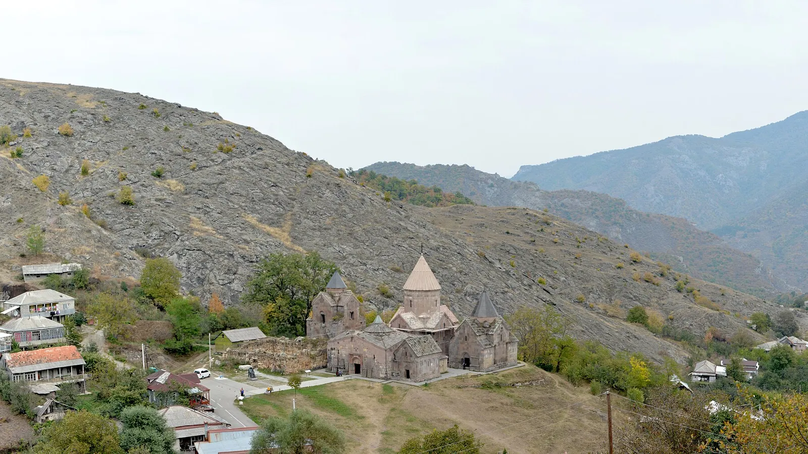
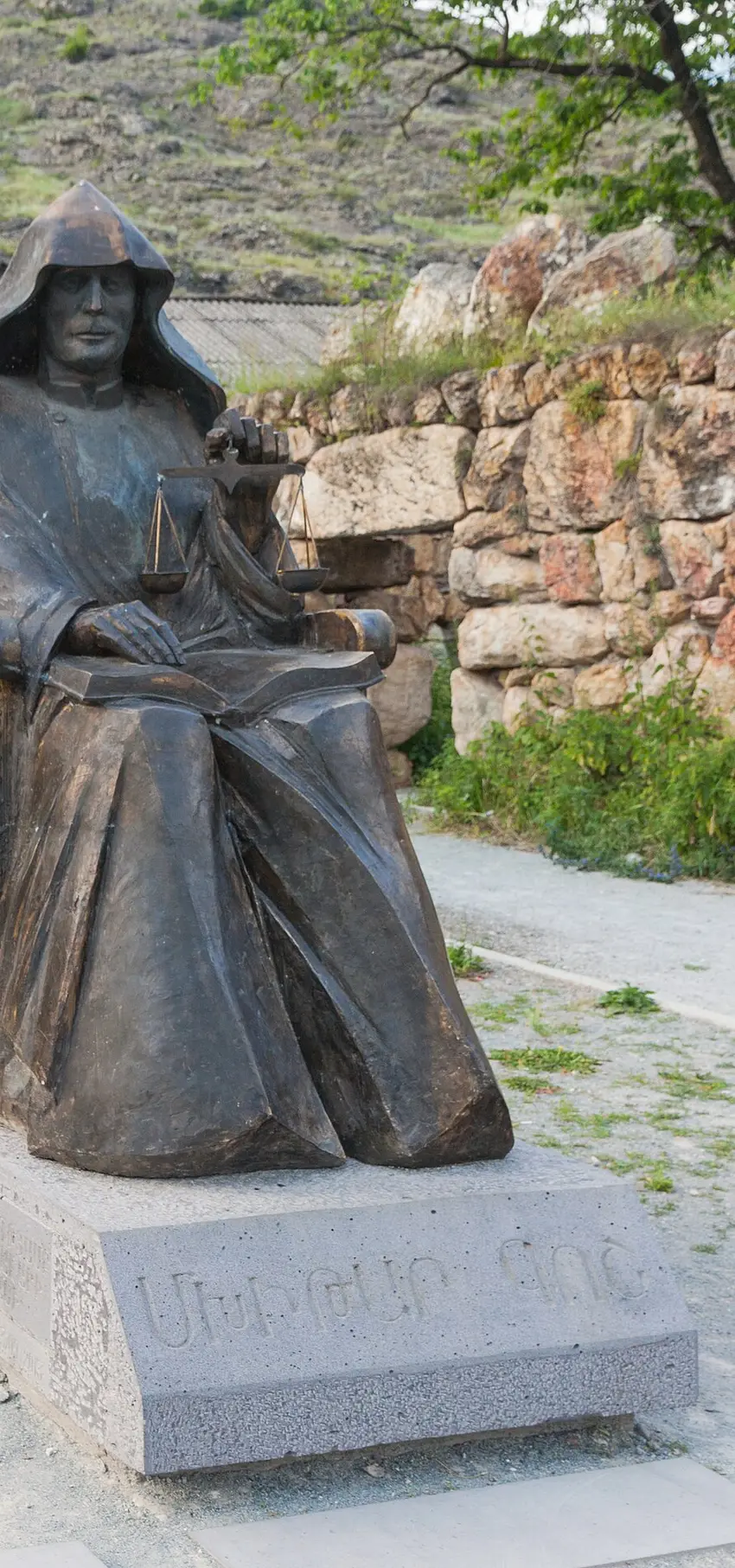
Mkhitar Gosh finished his Armenian law code sometime after 1184, working out of the monastery he founded in the hills above what’s now Dilijan, and the book outlived him by centuries: Armenian merchants in Kamianets-Podilskyi, a town of the Polish crown now in western Ukraine, were still being judged under his rules in the 1780s. Most write-ups skip past that for the carved khachkar out front, which has earned its billing. What gets shortchanged is Gosh himself: the school he ran, the grave on the hill almost nobody climbs to, the bronze figure holding an open law book and a set of scales. Goshavank stands in the village of Gosh, a short drive from Dilijan in northern Tavush province, and pairs with the better-known Haghartsin one valley over: two monasteries with tangled histories that look nothing alike.
Getik fell down, and Nor Getik went up somewhere else
This isn’t the monastery the earthquake hit. In 1188 the tremor brought down Getik, an older house elsewhere in the same river valley, in what’s now Gegharkunik province. Gosh, in his late fifties by then and long past his student years in Cilicia’s Black Mountains, judged the ruin beyond saving. The Armenian encyclopedia’s entry on Old Getik has him asking the Zakarid princes Zakare and Ivane for a different site altogether, and the brothers handing him the Tandzot gorge; he moved the community there in 1188 and called it Nor Getik, “New Getik”. What you walk into is a relocation, not a repair.
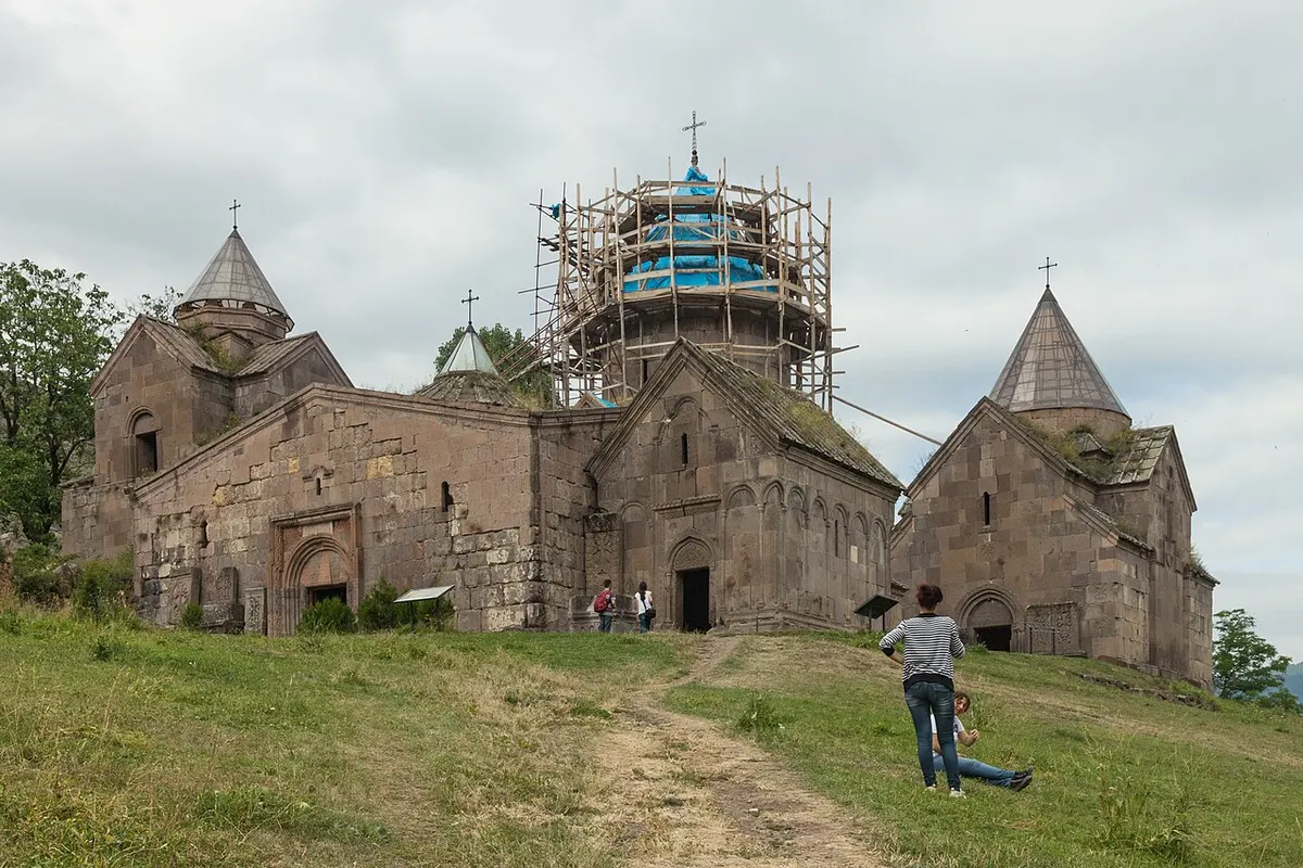
Surb Astvatsatsin, the main church, went up in 1191-1196 under the master builder Mkhitar Hyusn, paid for by the princes Kurd and Vakhtang of Khachen. The gavit, the covered hall that serves as entrance, meeting room and burial place, followed against its west wall in 1197-1203 on Zakare and Ivane’s money. Those two had already funded the rebuild at Haghartsin from 1184, which is the link most guides draw between the sites. There’s a better one, from Kirakos Gandzaketsi, a historian who studied here: when this monastery’s first church, a wooden one, was consecrated, Haghartsin’s abbot Khachatur Taronetsi turned up and handed it two villages and an orchard. The pairing sold as a day trip is eight centuries older than the itinerary.
Gosh ran the place until he died in 1213, and only then did it take his name. The village that grew up beside it counted 1,115 people at the 2011 census.
A law book that travelled further than its author
Take the architecture away and Goshavank still matters, because of a book. Gosh began compiling the Datastanagirk around 1184, pulling Armenian civil and canon law into one working text at a time when no Armenian state existed to enforce either. It held up: the Armenian Kingdom of Cilicia gave it the force of law in the 13th century, in the version Sempad the Constable reworked and presented in 1254. It went further still. In 1519 the Armenian community in the towns of the Polish crown put a Latin edition of the code in front of King Sigismund I the Old, asking to be judged under their own law, and he approved it with minor changes. The Internet Encyclopedia of Ukraine, which calls the result the Armenian Statute, says it stayed in force until 1780-1, and Armenian self-government in Kamianets-Podilskyi lasted to 1787. That’s two and a half centuries of a Tavush monk’s rulebook settling arguments between merchants there, close to six hundred years after he wrote it.
None of that happened away from the monastery. Gosh founded a school here while the building work went on, and Gandzaketsi came out of it: he lived through the Mongol invasions and wrote them down. Gosh wrote fables too, closer to Aesop than to jurisprudence, which looks odd until you remember what a medieval Armenian abbot did all day: run estates and settle arguments between neighbours. Don’t skip the statue either - it’s the most literal monument on the hillside.
St. Gregory has two churches here, and only one is a copy
Up close, Goshavank is a huddle of low buildings sharing party walls, no outer wall, village houses backing onto the yard. Two are dedicated to St. Gregory, and telling them apart trips up almost everyone - you’ll mix them up once before it sticks.
The plain one, St. Grigor, sits among the chapels on the south-east side and is easy to walk past. Armenia’s national tourism board calls it “an identical copy of the St. Astvatsatsin church in its architectural patterns and design”, and from the front the two domes do read as a pair. The showpiece is the other one: St. Grigor Lusavorich, Gregory the Illuminator, built against the south wall of the gavit in 1237-1241 at the expense of Prince Grigor-Tkha. Architecturally it’s a different animal. English Wikipedia, following the architectural historian Khalpakhchian, has it “true to the type of Armenia’s fifth-century basilicas”; the Armenian encyclopedia calls it a single-nave church under a barrel vault, a form already uncommon by the 13th century. It has no dome, and it’s the smallest church in the complex - which matters, because it also carries the heaviest carving of the lot: arcading round all four walls, twisted columns, and a west portal cut so finely that the impression, in Wikipedia’s phrasing, is that of openwork lace.
Left of the gavit, joined to it by an arched passage, stands the book depository: manuscripts in wall niches, finished by 1241. In 1291 the patrons Dasapet and Karapet swapped its wooden roof for two pairs of intersecting stone arches, strong enough to carry a second storey: a small cross-plan church, and a rotunda belfry on columns above it. The Armenian encyclopedia notes flatly that the columned belfry has not survived, so the profile you photograph is a level shorter than the 13th century’s. What the building started matters more: English Wikipedia records that this composition influenced the two-storey sepulchral churches raised at Yeghvard and Noravank in the second quarter of the 14th century. That two-storey silhouette - the one southern itineraries stop for - starts in a village library in Tavush. Don’t miss the book depository on the way round.
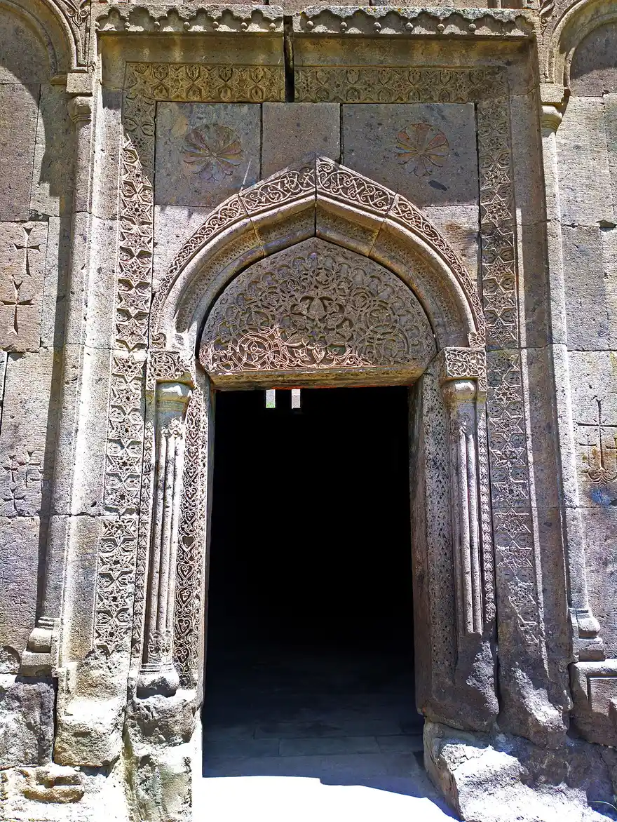
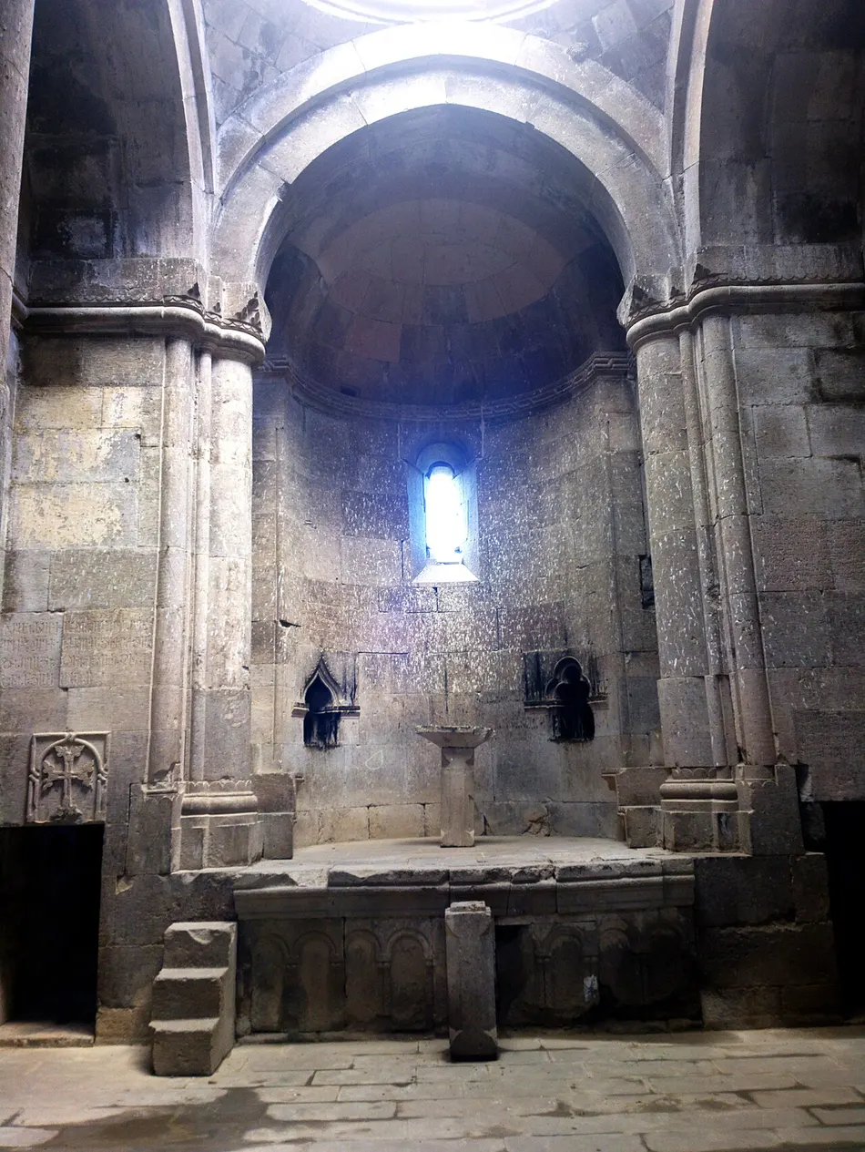
The khachkar they call “the embroidery”
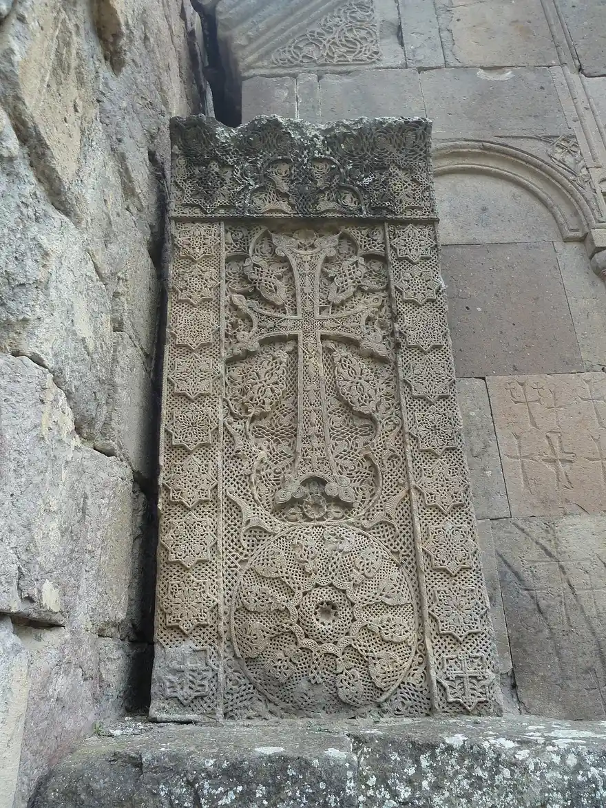
The khachkar every write-up leads with was carved in 1291 by a master named Poghos, and it earns the reputation. Armenians nickname it Aseghnagorts, roughly “needle-worked”, because the carving builds up in so many overlapping layers - a cross on a shield-shaped rosette, eight-pointed stars in the corners, a tight geometric lattice behind a looser floral pattern - that from a few paces the surface stops reading as stone. That’s the embroidery nickname earned. Poghos signed it: his name is cut into the bottom-left star, a small act of self-credit most khachkar carvers never got to make.
Fewer people know it had a twin. Two matching stones once stood either side of the entrance to the little Illuminator church; the southern one went to the History Museum of Armenia in Yerevan in 1935. Anyone who walked that museum before heading north has seen half of this pair without knowing it. Haghartsin, down the road, has fine khachkars of its own, and nobody claims they match Poghos’s work here; you’ll get more from comparing the two sites on one trip than from choosing between them.
The hillside tomb, and the climb to Gosh Lake
Gosh’s grave isn’t down among the tour groups. It’s on the hillside above the village, beside a small domed church of St. Gevorg that Khachatur Vardapet and Barsegh built next to his mausoleum in 1254. The tourism board puts the walk at about fifteen minutes, and almost nobody makes it - a shame twice over, because it’s the one spot that shows the whole cluster of domes and roofs from above, and where the man the place is named after lies.
Behind the monastery there’s a lake, and how far it’s depends on who you ask. The tourism board calls Gosh Lake a three-kilometre hike; HikeArmenia, the national trail database, maps the same trip as a marked route called “Oh My Gosh” and measures 4.2 km one way. Its own note puts the lake roughly 2.5 km from Gosh village, with jeep-track access or a trail, so the two figures probably describe different ways up.
Either way, you’re going up. HikeArmenia’s card lists a maximum height of 1,430 m and a minimum of 1,225 m, and those are the top and bottom of the route, not its ascent and descent - the top being the lake end. Three elevation models put the lake at 1,415-1,423 m and the monastery yard at 1,225-1,227 m, so the walk out gains around 200 m. HikeArmenia’s own time for the 4.2 km is 1 hour 40 minutes one way, which makes this a half-day, not the hour each way that “a 3 km hike” suggests. The database still rates it Easy, which at 200 m over four kilometres is fair. Dilijan National Park’s wider network, including a two-day route that ends here, is broken down trail by trail in our park hiking guide.
Getting there, and what the last stretch costs
Goshavank sits about 22 km from central Dilijan, a 25-minute drive on a paved side road off the Dilijan-Ijevan highway, and about 118 km, just under two hours, from Yerevan. Haghartsin is 20 km away by road, close enough that most people see both in a day. The last stretch is what needs planning.
Most visitors arrive on a day tour out of Yerevan that bundles Goshavank with Dilijan and Haghartsin, sometimes Lake Sevan, and takes the mountain driving off you. A rental car buys two things a tour won’t: as long as you like at the khachkar, and the choice to add the tomb climb or the lake. Without a car in Dilijan, the last leg is a taxi, and it helps to know the order of magnitude before you haggle. Yandex Go’s card for Yerevan - there’s none for Dilijan - caps the out-of-town fare at 130 AMD a km plus 15 AMD a minute, rounded up to the nearest 100: 22 km and 25 minutes comes to 3,300 AMD one way. Cards expire and get reissued, and the capital’s ceiling isn’t a Dilijan quote. The driver comes back empty, so agree a return with waiting built in. Getting as far as Dilijan, with marshrutka, taxi and transfer prices, is laid out in our Yerevan to Dilijan guide.
The bus question has two halves. On the map there’s a stop: OpenStreetMap marks one called Gosh-Dilijan, 75 m from the church door, on the H-30, a numbered regional road running on through the village towards Chambarak. But HikeArmenia’s directions for this valley tell you to take a taxi from Dilijan’s bus station up to Gosh, and the Tavush timetables the ministry has published online (11 of the 13 appendices) show no route to Gosh. Ask at your guesthouse the evening before, and keep a taxi fare in reserve for the way back.
The order to walk it in
The tourism board publishes a route through the complex, and it beats wandering: main church and gavit, left to the book depository, round the back for St. Grigor and the twin chapel cells, finish at the Illuminator church. Done that way the famous khachkar comes last instead of first, since it stands directly in front of that tiny building, and it lands harder once you’ve seen what it guards.
This is a working church of the Armenian Apostolic Church, not a museum, and Surb Astvatsatsin still holds liturgy on Saturdays and Sundays. The board’s page describes the visit and the services without naming a price or opening times; travellers report free entry, so bring small cash for the souvenir stalls and plan the visit for daylight. There’s no perimeter wall and no gate to find shut, but if quiet matters, come on a weekday morning: the weekend liturgies and the late-morning coaches both put more people in that yard than the approach path suggests.
Photos
On the map
The map loads on click - to keep the page lightweight.
The map didn’t load. Check your connection and refresh the page.
Admission and opening hours
- Admission price
- Reported free; no admission price is published. Carry small cash for the souvenir stalls.
- Opening hours
- The national tourism board lists no opening hours; plan a daylight visit. Liturgy at Surb Astvatsatsin on Saturdays and Sundays.
Souvenir stalls by the entrance, and a small ethnographic display of around 100 items beside the complex.
Details checked: August 29, 2026
Distance
- Yerevan ≈118 km · about 1 hour 55 minutes North on the M4 through Sevan and the Dilijan tunnel, then a side road east once you're through town. Most day tours from the capital fold this stop in alongside Haghartsin and Dilijan itself, so you won't have to drive it yourself.
- Dilijan ≈22 km · about 25 minutes A paved side road leaves the Dilijan-Ijevan highway and climbs into a forested valley to reach Gosh village. HikeArmenia's own directions for the area send you up that last stretch by taxi, so plan on a car, a taxi from town, or a tour that includes the stop.
Read also

What to see · 10 min read
Soviet Modernist Yerevan: An Architecture Walk
Verified · September 5, 2026Walk Yerevan's Soviet modernism: Rossiya Cinema, Komitas Hall, Cascade, Hrazdan Stadium and Demirchyan Complex - dates, route order, and what still stands.

What to see · 9 min read
Kond: Walking Yerevan's Oldest Neighborhood
Verified · September 3, 2026Walk Kond, Yerevan's oldest living quarter: Surp Hovhannes, Tepebashi mosque walls, Leo Street alleys, and how to visit without treating it like a set.
What to see · 8 min read
Sardarapat Memorial: Armenia's 1918 Battle Site
Verified · August 31, 2026Sardarapat Memorial near Armavir: 1918 battle site, Israelyan's red-tufa complex, ethnography museum tickets, hours and how to reach it from Yerevan.
What to see · 8 min read
Byurakan Observatory: Stargazing on Aragats
Verified · August 26, 2026Visit Byurakan Observatory on Mount Aragats: day tours, the 2.6m telescope, night stargazing prices and how to book ahead on bao.am.