Yeghegis Valley Loop: Smbataberd & Selim Pass
A 1-2 day self-drive loop into a medieval side valley of Vayots Dzor: the Selim Pass caravanserai, Smbataberd fortress, Tsakhats Kar and Yeghegis.
Most people drive through Vayots Dzor on the way to Tatev and never turn off. That is the whole appeal of this loop: it leaves the main southern highway for a quiet medieval side valley that many visitors miss entirely. In one arc it takes in the Selim Pass caravanserai, a 700-year-old Silk Road inn on a 2,410 m pass; the ridge-top fortress of Smbataberd; the hillside monastery of Tsakhats Kar; a 13th-century Jewish cemetery by the river; and the strangest small church in Armenia, roofless Zorats. It runs about 360 km round trip from Yerevan, and it rewards a slow two days far more than a rushed one.
This is a self-drive route, and it needs to be. There is no useful public transport up to the pass or into the Yeghegis valley, the sights are strung along small mountain roads, and the last stretch to Smbataberd is a rough track you finish on foot. One important caveat before you commit: the Selim (Vardenyats) Pass is a high, serpentine road that closes in winter and after heavy snow. From roughly May to October it is a glorious drive; outside that, check the road status first, or skip the pass and come into the valley from the Yeghegnadzor side instead.
Which way to drive it
There are two ways to string this together, and both are good. The classic scenic version comes down over the Selim Pass from the Lake Sevan side on the M10, so you crest the pass, meet the caravanserai, and descend into Vayots Dzor with the valley opening below you. From Yerevan the simpler version runs south on the M2 to Yeghegnadzor (about 123 km), turns up into the Yeghegis valley for the fortress and monasteries, and drives up to the pass and back as an out-and-back. Either way the caravanserai is the set-piece and the valley is the heart. I have written it below as pass-first, but flip it freely.
The Selim Pass and Orbelian caravanserai
The Selim Pass (officially renamed Vardenyats in 2014) tops out at 2,410 m, and just below the summit stands the reason to stop: Orbelian’s caravanserai, built in 1332 by prince Chesar Orbelian to shelter merchants and their animals on the Armenian leg of the Silk Road. It is the best-preserved caravanserai in the country, and stepping inside is the closest thing Armenia has to time travel.
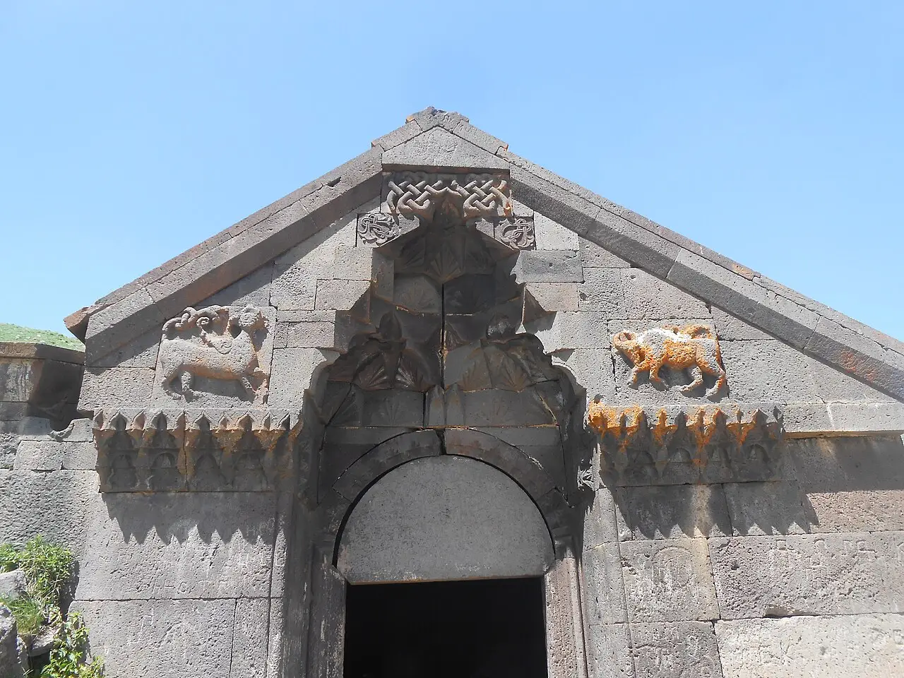
Built of dark basalt, it is a single long hall split into three naves by seven pairs of stone pillars, windowless and cave-cool even in August - which is exactly the point, since it had to keep men and pack animals alive through blizzards up here. Duck through the low carved doorway and let your eyes adjust; the light comes only from the entrance and a few roof slits, and the effect is genuinely medieval. Outside, the pass itself is the other half of the experience: a bare, wind-scoured saddle with enormous views, lammergeiers overhead, and switchbacks that make it one of Armenia’s great drives. Bring a layer even in summer.
Smbataberd: a fortress you climb to
Drop off the pass into the Yeghegis valley and make for Smbataberd, a fortress on a long ridge between the villages of Artabuynk and Yeghegis, with the Artabuynk and Yeghegis rivers cutting the gorges on either side. You can drive a rough track a good way up from Artabuynk, then it is a short, steep walk to the walls - allow a couple of hours for the round trip and wear real shoes.
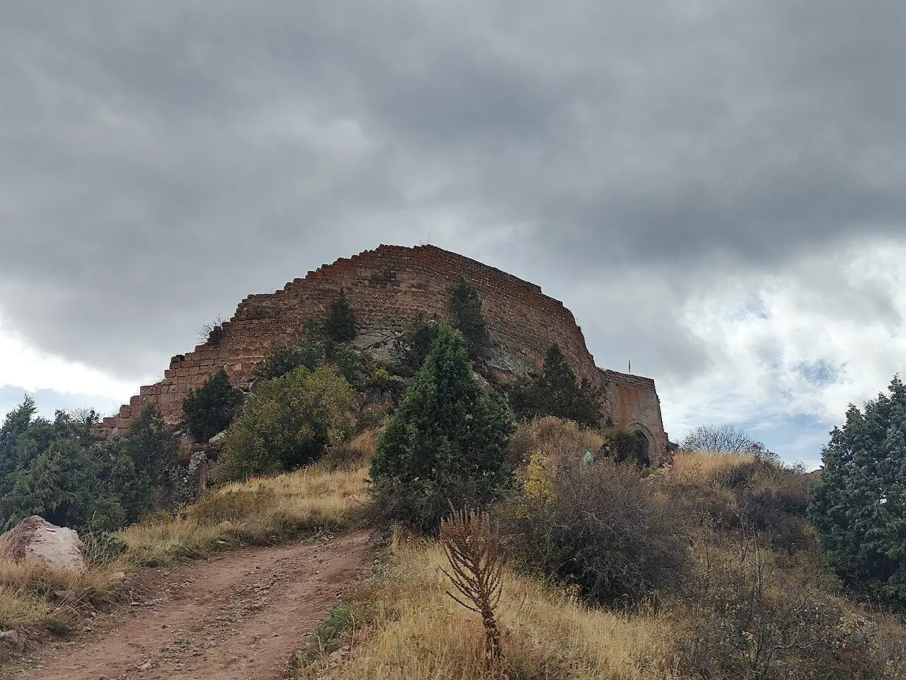
The reward at the top is both the view - the whole valley laid out, the mountains stacked behind - and the sheer bulk of the place: walls two to three metres thick, half-round towers eight to ten metres high, riding the natural rock at around 2,000 m. Its exact age is argued over (foundations may be as old as the 5th century, with the surviving fortifications largely 10th to 13th), but the best-told part is how it fell. Perched up here it looked impregnable, so the story goes that the Seljuks simply cut the buried water pipe feeding the fortress after a thirsty animal led them to its hidden source, and thirst did what siege could not. Whether or not that is literally true, standing on the ramparts you understand instantly why they had to go for the water.
Tsakhats Kar and the medieval valley
A little further along the same ridge, northeast of Artabuynk, sits Tsakhats Kar, a monastery founded in 1041 and quietly restored, scattered with khachkars (carved cross-stones) and older animal carvings that reward a close look.
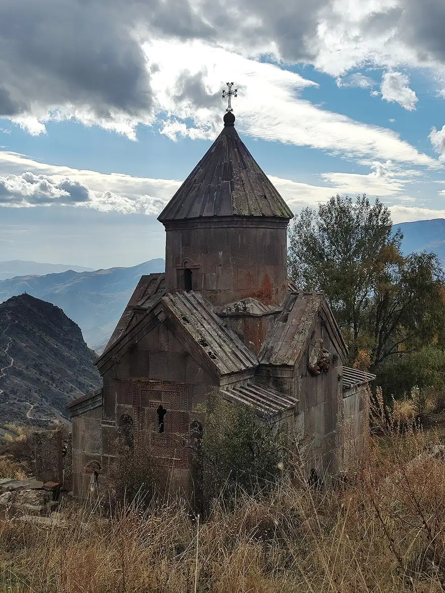
It pairs naturally with Smbataberd - the two are the standard hiking loop from Artabuynk, a walk of around 16 km if you do the whole circuit on foot rather than driving up. Down in the valley, Yeghegis village itself was no backwater: in the 13th and 14th centuries it was the seat of the Orbelian dynasty, who ruled much of the south, and the valley is thick with their churches and khachkars. If you like your monastery-hopping structured, our roundup of the best monasteries in Armenia puts these lesser-known sites in context alongside the headline ones.
A 13th-century Jewish cemetery
The most unexpected stop is a small walled field by the river below Yeghegis: a medieval Jewish cemetery, one of the oldest known in the region, its carved gravestones dating from the 13th to 14th centuries (the excavated stones span 1266-1347).
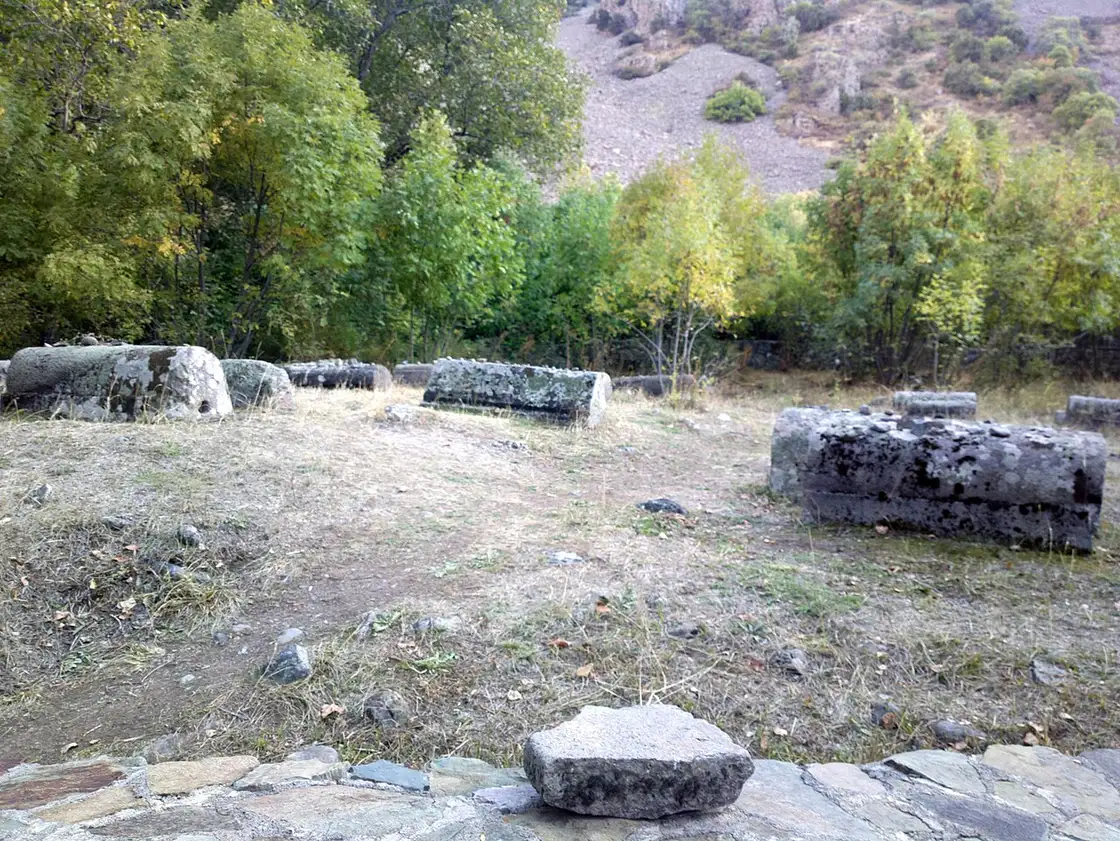
It is a genuinely surprising thing to find in a remote Armenian valley, and it tells you how connected this place once was - a trading community living here under the Orbelians, with headstones cut in Hebrew and Aramaic. The stones were studied and conserved by scholars a couple of decades ago, and there is a quiet dignity to the spot. It takes only a few minutes, but it is the kind of detour that makes a trip memorable precisely because nobody expects it.
Zorats: the church with no roof
Finish in the village at Zorats Church, built in 1303, and unlike any other church you will see in Armenia. It has no inner hall at all: only the altar and two small side chambers are roofed, and the rest stands open to the western sky.
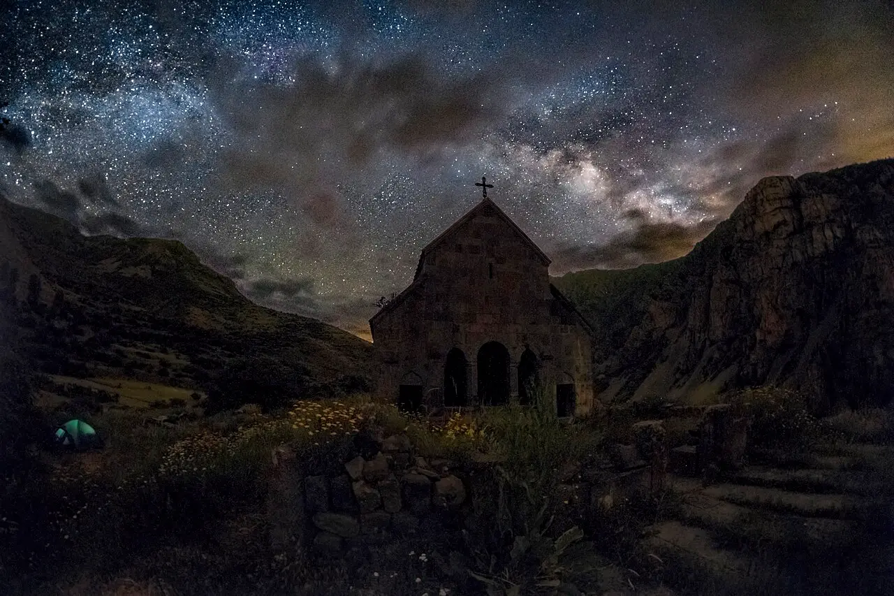
The design was deliberate and, once explained, rather brilliant. The altar was raised to the height of a soldier on horseback, so that troops could be blessed before a campaign without dismounting - the whole cavalry lined up in the open forecourt at once. The name Zorats means “of the army,” and it is said to be the only church in Armenia built for that purpose. Stand where the horsemen stood, with the valley falling away west, and the odd empty plan suddenly makes complete sense. From here it is back down to Yeghegnadzor and the M2 north to Yerevan, or on south if you are continuing your trip.
Costs, timing and how to combine it
Money here is really about the car and one night, since every sight on the loop is free: the caravanserai, Smbataberd, the monasteries, the cemetery and Zorats all cost nothing to walk into. As a rough floor, a relaxed two-day version on that footing starts around AMD 65,000 per person for two sharing, and climbs with a bigger car, nicer rooms and more meals out. Two costs are easy to under-budget on this particular route, so build them in: fuel is higher than the distance suggests, because the long haul up to the Selim Pass and back burns more than flat kilometres, and where you sleep swings the total. A guesthouse down in the Yeghegis valley keeps you among the villages and monasteries for an early start, while Yeghegnadzor, back on the M2, has more rooms and food if the valley is booked out. Whatever number you land on, treat it as a starting figure, not a quote.
The car is the one thing you cannot skip, and the pass makes the choice of car matter more than usual. Over the Selim serpentines a low, underpowered hire car will struggle on the climb, and if there is any chance of an early or late-season snow window you want a vehicle that can cope; our guide to renting a car in Armenia walks through the deposit, the insurance excess and what to ask for when a 2,410 m pass is part of the plan.
The one-day version is possible from Yerevan but honestly rushed, especially if you walk up to Smbataberd, so if you only have a day, cut the fortress hike or the pass rather than skimping on the valley. The loop also plugs neatly into a southern trip. It sits right next to the wine country: Areni and Armenian wine are a short drive west, and the red-cliff monastery of Noravank is just down the main road, so many people fold Yeghegis into a Vayots Dzor day and stay the night. The spa town of Jermuk, with its mineral springs and waterfall, is further south in the same province and makes an easy add-on. And because you crest the Selim Pass from the north, it links naturally to Lake Sevan on the far side. For a full trip that threads all of this together, see our 10-day Armenia itinerary, or browse the routes hub for more ways to build one.
Route day by day
- Days on the road
- 2
- Distance
- ≈360 km
- Budget from
- 65000 AMD
- Best season
- May, June, July, September, October
-
Yerevan
Route startstop ≈0 min
Start point: head south on the M2 toward Vayots Dzor, then turn up for the Selim Pass.
-
Selim Pass caravanserai
120 km from the startstop ≈60 min
The best-preserved caravanserai in Armenia (1332), a basalt Silk Road inn at 2,410 m on the Selim (Vardenyats) Pass.
Photo: Mari Avetisyan / Wikimedia Commons, CC BY-SA 4.0 (source) -
Smbataberd fortress
150 km from the startstop ≈150 min
A ridge-top fortress between Artabuynk and Yeghegis, its main walls 10th-13th century, taken by cutting its water pipe; short steep hike up.
Photo: Avetisyan Ani / Wikimedia Commons, CC BY-SA 4.0 (source) -
Tsakhats Kar monastery
153 km from the startstop ≈60 min
A hillside monastery founded in 1041, with khachkars and carvings, on the ridge northeast of Artabuynk.
Photo: Avetisyan Ani / Wikimedia Commons, CC BY-SA 4.0 (source) -
Yeghegis (Jewish cemetery)
158 km from the startstop ≈40 min
The old seat of the Orbelian dynasty; a 13th-century Jewish cemetery by the river, one of the oldest known in the region.
Photo: Soghomon Matevosyan / Wikimedia Commons, CC BY-SA 4.0 (source) -
Zorats Church
159 km from the startstop ≈30 min
A unique open-air church of 1303 whose nave has no roof: the raised altar let mounted soldiers be blessed before battle.
Photo: Foton095 / Wikimedia Commons, CC BY-SA 4.0 (source)
Route map
The map with stops loads on click - to keep the page lightweight.
The map didn’t load. Check your connection and refresh the page.