Best Hikes in Armenia
The best hikes in Armenia, from the easy Symphony of Stones walk to the volcanic summits of Aragats, Azhdahak and Khustup, and how to pick one by season.
Armenia is one of the most rewarding places to walk in the whole Caucasus, and the best hikes split into two very different kinds: gentle valley and gorge trails you can do in an afternoon, and high volcanic summits that ask for a full day, some fitness and a careful eye on the weather. The pick of them are the drive-up alpine country of Mount Aragats, the crater lake on Azhdahak in the Gegham range, the demanding ridge of Mount Khustup above Kapan, the fortress-to-monastery loop at Smbataberd, and the waymarked forest paths of Dilijan. This guide runs through the ones worth your time, sorted so you can match a trail to your fitness and your dates, because in Armenia the season decides more than the map does.
The one rule that shapes everything is altitude and snow. The headline summits are all high, bare and volcanic, and their realistic window is narrow: roughly late June or July to late September, once the snow has melted off the tops and before it returns. Go too early and the high trails are under snow; the lower forest and gorge walks, by contrast, open far earlier and hold on later. So read this less as a ranking and more as a menu you order from according to the month you are here and how hard a day you want.
Easy walks: gorges, lakes and forest strolls
You do not need to bag a peak to get the best of walking here. The most popular easy outing is the Symphony of Stones in the Garni Gorge, a short trail from Garni village down to a wall of towering hexagonal basalt columns, some rising as much as 50 metres, formed as ancient lava cooled and cracked. It is roughly a 2 km walk in, about half an hour each way on a rough track, and suitable for almost anyone; our guide to Garni temple and Geghard monastery covers how to fold it into a half-day from Yerevan.
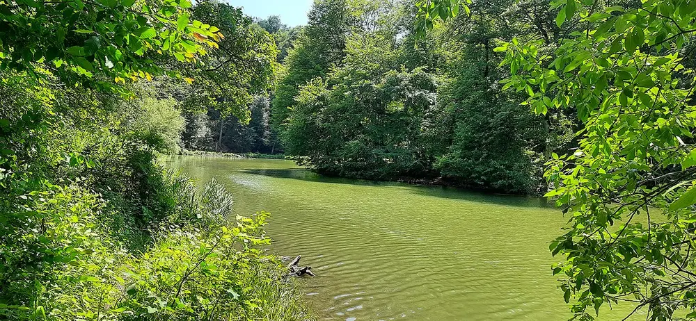
In the north, the forests around Dilijan are laced with gentle paths. A classic short one loops around Parz Lake (Parz Lich), a small emerald lake ringed by beech woods, and longer forest trails link it toward the monasteries of Goshavank and Haghartsin. The town itself, often called Armenia’s “Little Switzerland,” makes the natural base for a couple of days of easy walking; our Dilijan guide has the trails, the monasteries and where to stay. These low, shaded walks are also the answer in high summer, when the volcanic tops are baking or thunderstorm-prone and the beech canopy stays cool.
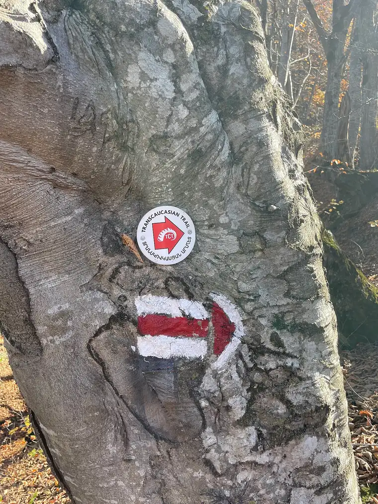
The Transcaucasian Trail through Dilijan
If you want a proper multi-day walk without going full expedition, the Transcaucasian Trail (TCT) is the one to know. Its Dilijan National Park section runs about 80 km over four to five days through beech forest and open ridges, and crucially it is the only substantially waymarked long-distance path in the country: look for the red-and-white painted blazes and the round TCT arrow markers on trees and rocks, with signposts at the major junctions. You can walk it in either direction, and because it is signed you can also just do a day-section of it as an out-and-back rather than the whole thing.
Do not mistake waymarked for easy, though. The trail crosses steep terrain and turns serious in bad weather, with real route-finding in places, summer thunderstorms that build fast, river crossings that can be dangerous in high water, patches of giant hogweed (whose sap burns skin in sunlight), and the shepherd dogs you meet all over the Armenian hills. Carry a downloaded map, start early, and treat the weather with respect.
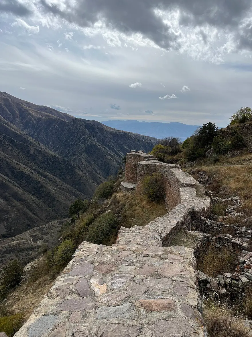
Smbataberd and Tsakhats Kar: the best moderate day
For a single big-payoff day that does not require a summit, the loop between Smbataberd fortress and Tsakhats Kar monastery in the Yeghegis valley of Vayots Dzor is hard to beat. Smbataberd is a dramatic hilltop fortress, traditionally dated to the 5th century, perched on a narrow ridge at about 1,950 m, its restored walls dropping away on both sides into deep valleys, and from there the trail runs down and back up to the remote 10th-century Tsakhats Kar monastery. The full loop is around 14 km with something like 680 m of climbing, and most walkers give it about five hours. It is a genuine mountain walk rather than a stroll, but well within reach of anyone reasonably fit, and it strings together a fortress, a monastery and huge valley views in one outing.
Mount Aragats: the roof of Armenia, the easy way
The country’s highest mountain, Mount Aragats, gives you high-alpine hiking with an unfair head start, because a paved road climbs to Lake Kari at about 3,200 m, so you begin the walk already near the top. From there the southern peak (about 3,888 m), the lowest of the mountain’s four summits, is the standard day-hiker’s objective, a demanding high-altitude walk rather than a technical climb. The other three peaks, and the traverse of all four around the collapsed central crater, are a serious mountaineering undertaking.
Because Aragats has its own full guide, this is the short version: it is the most accessible way to stand on genuinely high ground in Armenia, the road and hike are open only from roughly mid-May to mid-October, and it makes a superb day out of Yerevan. For the trail detail, the drive up, Amberd fortress on the way and everything else, see our dedicated guide to Mount Aragats and Lake Kari.
Azhdahak and the Gegham Mountains
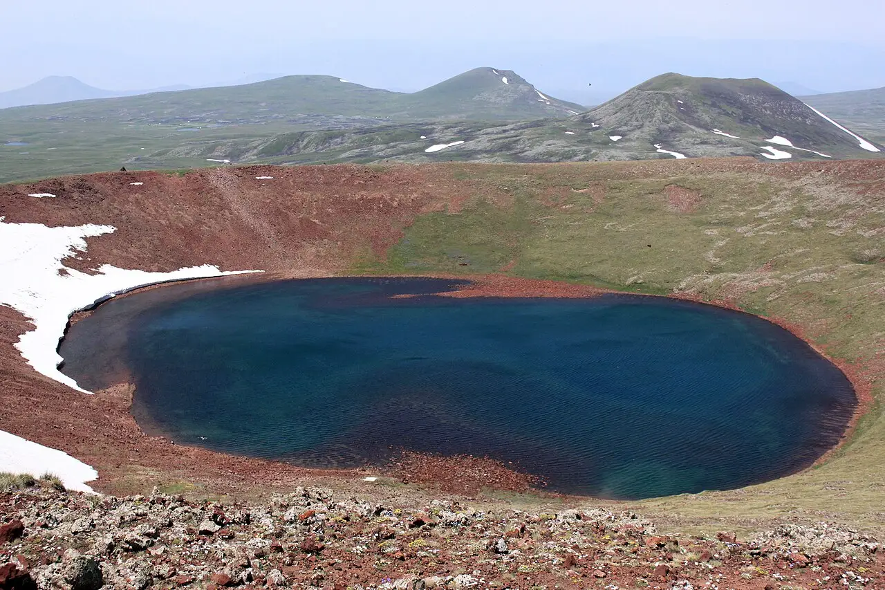
The Gegham (Geghama) range is the wild heart of Armenian hiking: a high volcanic plateau east of Yerevan, dotted with crater lakes, ancient rock carvings (petroglyphs) and grazing shepherds, with almost no infrastructure. Its highest point is Mount Azhdahak at about 3,597 m, the third-tallest peak in Armenia, a dormant volcano with rusty-red slopes and, sitting in its summit crater, a small, startlingly blue snowmelt lake. The summit hike is about 12 km round trip with roughly 600 m of ascent, and the sweet spot is July, when the meadows come alive with wildflowers.
For strong walkers this is also the setting for Armenia’s great wilderness trek: the Gegham traverse, roughly 50 km over three to four days of remote camping across alpine meadows, past crater lakes and petroglyph fields and over volcanic peaks including Azhdahak. There are no huts and no reliable signage, water and navigation take planning, and few international companies run it, so most people go with a local hiking outfit. Getting to the range at all means a rough vehicle track from the Geghard side toward the base of the peaks, then walking, so a guide with a 4x4 solves two problems at once.
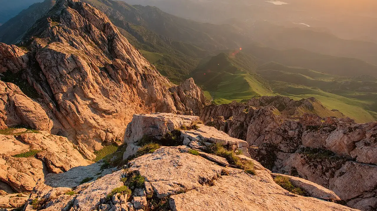
Mount Khustup: the south’s hardest classic
Down in the far south, above the mining town of Kapan, Mount Khustup rises to about 3,201 m and fills the local skyline much as Ararat looms over Yerevan. It is the region’s bucket-list summit and a genuinely tough day: steep, long, and often done over two days with a tent, though fit hikers tackle it from a high trailhead as one very long day. The usual approach is a 4x4 track up to Storot from Kapan, from where the summit is roughly six to seven hours up and down. The mountain carries real meaning for Armenians too: relics of the revered commander Garegin Nzhdeh are buried here, at his own wish, so that his spirit might go on watching over Syunik.
This is a hike for experienced walkers with a head for a long, exposed day, not a casual outing, and it rewards the effort with some of the finest summit views in the country, as the cover of this guide suggests. Because it is so far south, it pairs naturally with a wider trip through Syunik and the monasteries of the deep south rather than a day out of the capital.
How to choose, and how to stay safe
Start from your fitness and your dates. For an easy half-day, take the Symphony of Stones or a Parz Lake forest loop; for a rewarding moderate day that any fit walker can manage, the Smbataberd to Tsakhats Kar loop is the standout. For high country, Aragats is the most accessible summit thanks to that road to 3,200 m, Azhdahak the most spectacular for its crater lake, and Khustup the toughest single-day classic. If you want to keep walking for days, the waymarked TCT in Dilijan is the manageable choice and the Gegham traverse the true wilderness one. And if you are here in high summer, lean toward the forest and gorge walks by day and save the exposed tops for a settled early morning.
A few safety realities apply to all the high routes and are worth taking seriously. The summit trails are mostly unmarked (the TCT is the exception), so carry a GPS or a downloaded offline map, and consider a local guide; the free HIKEArmenia service, which runs an information centre in Yerevan and publishes trail data, is the best starting point. Acclimatise if you are jumping straight to 3,500 m, start at dawn because cloud and thunderstorms build through the afternoon, and remember there is no shelter and no water on the bare tops. Weather turns fast and cold up high even when Yerevan is hot, so carry warm and windproof layers, sun protection and more water than you think, tell someone your plan, and turn back without ego if the sky closes in. Match your outing to the right month with our guide to the best time to visit Armenia, and because these are high, remote objectives, make sure your cover fits: our guide to travel insurance for Armenia explains when hiking needs an adventure add-on.
One last practical point that catches hikers out: there is no public transport to any of these trailheads. Reaching Lake Kari, the Gegham plateau, Yeghegis or the Khustup track means your own vehicle or a tour, so either rent a car to reach them under your own steam, or join a guided hiking day trip that handles the driving and the route-finding. Our guide to getting around Armenia sets out the wider transport picture, but for the mountains specifically, plan on four wheels of your own or someone else’s.
Photos
Read also
Armenia Residence Permit: A Guide
Verified · July 4, 2026How to get an Armenia residence permit: the temporary, permanent and special types, the grounds, documents, fees and timeline, and the 2026 reform.
Taxes for Foreigners in Armenia
Verified · July 4, 2026Taxes for foreigners in Armenia: the 183-day residency rule, the 20% income tax, sole-trader and micro-business regimes, and the IT tax break.

Armenia Visa & Entry Rules (2026)
Verified · July 4, 2026Armenia visa and entry rules in 2026: who is visa-free for 180 days, the e-visa for everyone else, passport rules and the closed land borders.
Armenia Weather by Month
Verified · July 4, 2026Armenia weather month by month: average temperatures, rain and what is open or closed, from snowbound January to the golden harvest of October.