Mount Aragats and Lake Kari
How to visit Mount Aragats and Lake Kari: the drive-up alpine lake at 3,200 m, the four peaks, Amberd fortress and Byurakan, and the easiest summit hike.
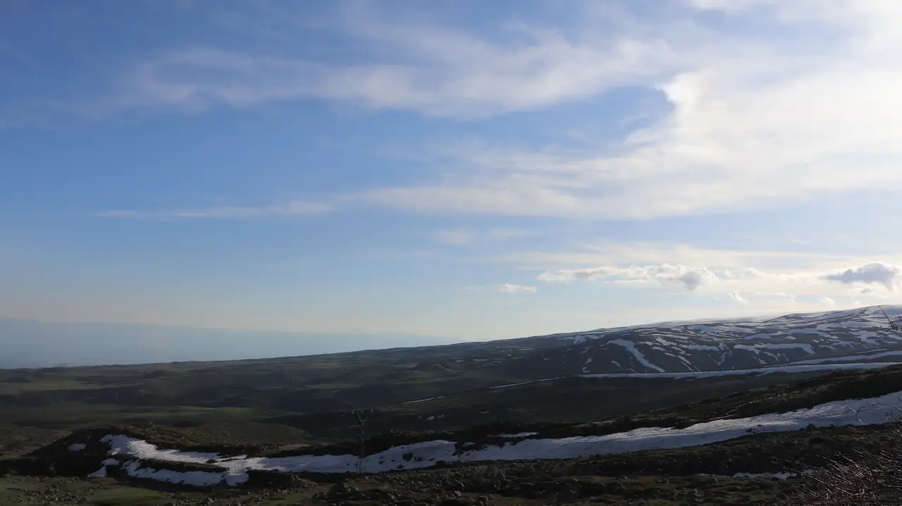
Mount Aragats is the highest mountain in Armenia, and Lake Kari is the reason most people who are not serious hikers get to see it up close. Aragats is a huge, dormant four-peaked volcano northwest of Yerevan, its northern summit topping out at 4,090 m, the highest point in the country and in the whole Lesser Caucasus. Lake Kari is a small alpine lake sitting at about 3,200 m on its upper slopes, and the good news is that a paved road runs all the way up to it. That means you can drive from Yerevan to genuine high-mountain scenery in under two hours, no climbing required, with a medieval fortress and one of the country’s oldest observatories on the way. This is how to make a day of it, and what to know before you go up.
The single most important thing to understand is that this is a seasonal, high-altitude trip. The road to Lake Kari is generally open only from around mid-May to mid-October, and snow can linger into September and return early. Even in summer it is cold and windy at 3,200 m when Yerevan is baking, so this is a jacket-and-layers outing whatever the forecast in the city. Go in July or August for the best odds of a clear, open road; outside that window, assume the top may be shut.
The four peaks and the shape of the mountain
Aragats is not a single cone but a ring of four summits standing around a collapsed central crater, which is what gives it that broad, sprawling profile you see from half of central Armenia. The northern peak is the highest at 4,090 m, followed by the western at about 3,995 m, the eastern at roughly 3,908 m, and the southern at about 3,888 m. That southern peak is the lowest and the one most day-visitors aim for, because it is the most reachable on foot from Lake Kari.
You do not have to climb anything to enjoy the mountain. For most visitors the drive itself is the attraction: the road climbs out of the orchards and vineyards of the plain, up through bare volcanic uplands where herders graze in summer, to the lake and the thin, bright air at the top. The temperature drop as you gain height is dramatic, and the views back over the plain, on a clear day all the way to Mount Ararat across the border, are the payoff.
Lake Kari
Lake Kari, whose name means “stone lake,” sits at about 3,200 m and is roughly a kilometre across, a cold, clear pool fed by snowmelt and ringed by rough volcanic ground. It is the end of the paved road and the natural base for everything higher up. There is usually a simple cafe here in season serving khash, trout and tea, which is a welcome thing at this altitude, and it is where hikers gather before setting off for the summits. On a still day the water mirrors the surrounding slopes; on a typical day it is windy and bracing, and you will be glad of that extra layer.
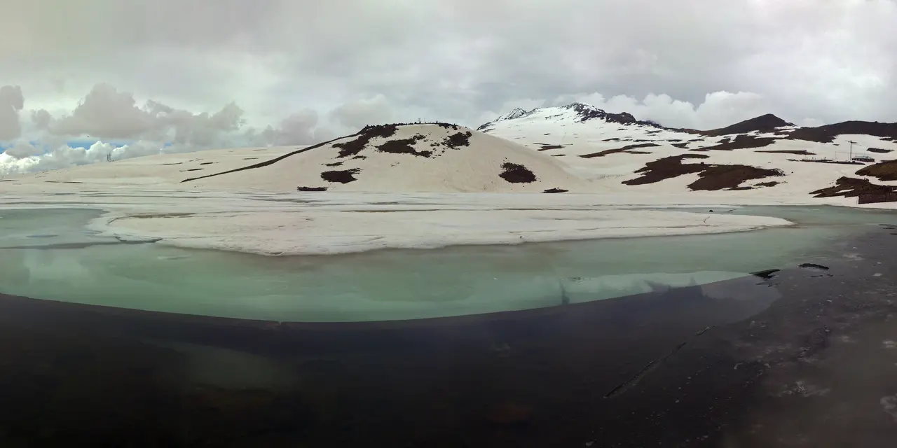
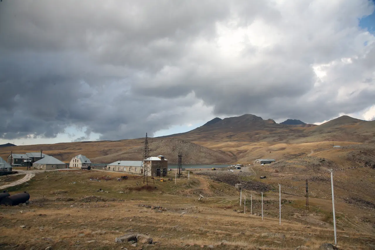
Right beside the lake sits the Aragats Cosmic Ray Research Station, a working physics observatory founded in 1943 that studies particles from space at this high, clear altitude. It is a real scientific facility rather than a tourist site, but its presence up here, along with the weather station, tells you why the spot matters beyond the scenery: thin air and dark skies make it valuable to science.
Hiking the southern peak
If you want to climb, the southern peak (about 3,888 m) is the one to aim for, and it is the easiest of the four to reach from Lake Kari. Do not let “easiest” fool you, though: it is still a high-altitude hike of roughly 11 to 13 km round trip with something like 680 m of ascent, and most people take about four to five hours there and back. The trail is unmarked in places, the weather turns fast, and the altitude makes it harder work than the numbers suggest, so it is rated a demanding walk rather than a stroll. The realistic season is roughly July to September, once the snow has cleared and before it returns.
Come prepared: proper footwear, warm and windproof layers, water, sun protection and an early start, because clouds and wind often build in the afternoon. Check the forecast, tell someone your plan, and turn back if the weather closes in, since there is no shelter up high. Reaching the other three, higher peaks, and the traverse of all four, is a serious mountain undertaking for experienced, well-equipped walkers and often a guide, and well beyond a casual day trip. For most visitors, the lake, the views and perhaps the southern peak are plenty. If you would rather match this to the right month, our guide to the best time to visit Armenia sets out when the high country is open and pleasant. And if the southern peak leaves you wanting more, our roundup of the best hikes in Armenia sets Aragats beside the crater lake on Azhdahak, the Khustup ridge and the Smbataberd loop.
Amberd fortress on the way up
The best stop on the drive is Amberd, a ruined medieval fortress on a spur of the mountain at about 2,300 m, wedged between two river gorges. The castle and its first walls were probably built in the 7th century by the noble Kamsarakan family; in the 10th century it passed to the Pahlavuni princes, and it reached its height under Vahram Pahlavuni in the 11th century before the Mongols wrecked it in 1236 and it was finally abandoned after Tamerlane’s invasions. It is a dramatic, windswept spot with big views, and it makes the perfect leg-stretch on the way to or from the lake.
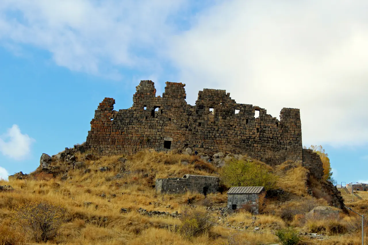
Right next to the fortress stands the Vahramashen church (Surb Astvatsatsin), built by Vahram Pahlavuni in 1026 and still standing in fine condition, a classic compact Armenian church of the great medieval period. Because it is a monastery-era church on the way to the country’s highest mountain, Amberd earns a mention among Armenia’s finest; our roundup of the best monasteries in Armenia sets it in the wider picture of the country’s medieval architecture.
The Alphabet Park and the science on the slopes
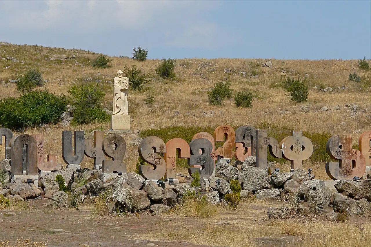
The other thing worth a stop is the Armenian Alphabet Park near the village of Artashavan, on the lower approach to the mountain. It was created in 2005 to mark the 1,600th anniversary of the Armenian alphabet, and it is a field of 39 giant carved stone letters, one for each character Mesrop Mashtots devised, dotted with statues of Armenian scholars. It is a quick, characterful photo stop and a nice piece of national pride to fold into the day, especially if you are travelling with anyone curious about the script you see on every sign in the country.
The southern slopes also hold the Byurakan Astrophysical Observatory, founded in 1946 by the astronomer Viktor Ambartsumian at around 1,405 m near Byurakan village, one of the significant observatories of the Soviet era. It is a working institution rather than a walk-in attraction, but it is part of what makes this side of the mountain a corner of Armenian science as much as scenery.
How to visit
Aragats is about 60 km northwest of Yerevan, and Lake Kari is roughly a 1.5 to 2 hour drive up a paved road via Byurakan. The snag, as with most of Armenia’s best scenery, is that there is no public transport to the lake or the peaks, so you need your own wheels or a tour. Renting a car gives you the freedom to stop at Amberd, the Alphabet Park and the viewpoints at your own pace, and to time the summit for the morning; our guide to car rental in Armenia covers the paperwork and the mountain-road realities. If you would rather not drive a high mountain road, a guided Aragats and Amberd day trip takes the wheel and the route-finding off your hands.
Fold it into a trip the way locals do: a high-country day that contrasts nicely with the monasteries and the wine. It sits well alongside the other outings in our roundup of the best day trips from Yerevan, and the city sights you might pair it with are laid out in our guide to things to do in Yerevan. One last thing before you set out: this is a mountain that shuts without warning, so check that the road above Byurakan is open on the morning you go, don’t count on the lakeside cafe outside high summer, and leave early while Ararat is still clear across the plain, because the driving is the point and the weather up top writes the rest of the day.
Photos
On the map
The map loads on click - to keep the page lightweight.
The map didn’t load. Check your connection and refresh the page.
Distance≈60 km · 1.5-2 h by car
- Yerevan≈60 km · 1.5-2 h by carPaved road up to Lake Kari via Byurakan; no public transport to the lake or peaks.
Read also
Best Monasteries in Armenia
Verified · July 4, 2026How to choose between the best monasteries in Armenia: Khor Virap, Geghard, Tatev, Noravank, Sevanavank and the UNESCO north, grouped by region.
Northern Armenia: Lori, Haghpat & Sanahin
Verified · July 4, 2026What to see in Lori, northern Armenia: the UNESCO monasteries of Haghpat and Sanahin, Odzun, the Debed canyon, Lori Berd and Tumanyan country in Dsegh.
Dilijan: Armenia's Little Switzerland
Verified · July 3, 2026Visiting Dilijan, Armenia's forested spa town: Haghartsin and Goshavank monasteries, the Sharambeyan craft quarter, hiking, and getting there from Yerevan.
Garni Temple & Geghard Monastery: Day Trip from Yerevan
Verified · July 3, 2026Garni and Geghard in a half-day from Yerevan: the only Greco-Roman temple in the region, a cliff-carved UNESCO monastery, Symphony of Stones and lavash.